National Weather Service United States Department of Commerce

Preliminary Statement on Recent Severe Weather and Flooding Impacts

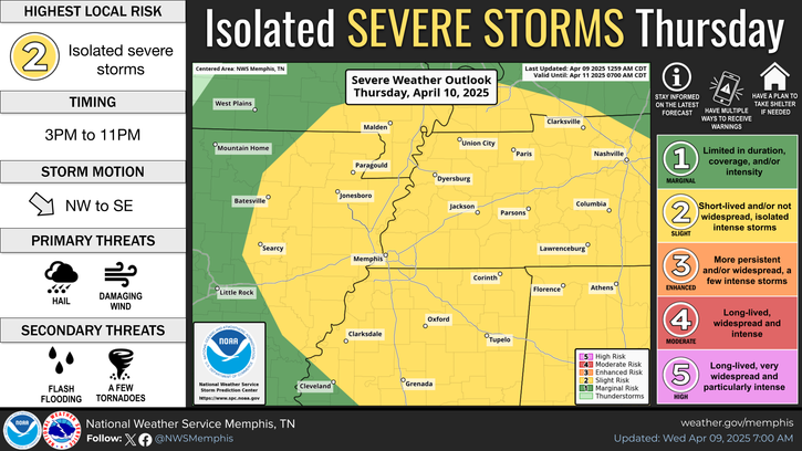
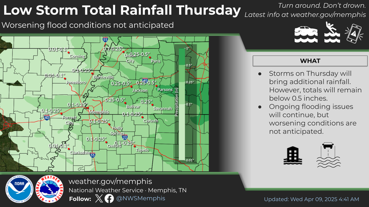
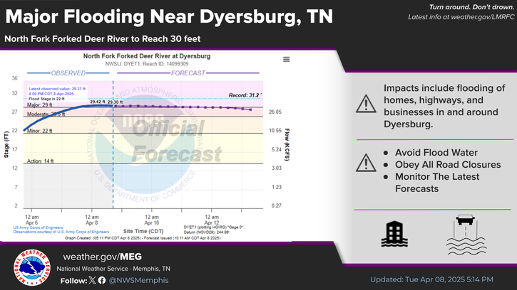
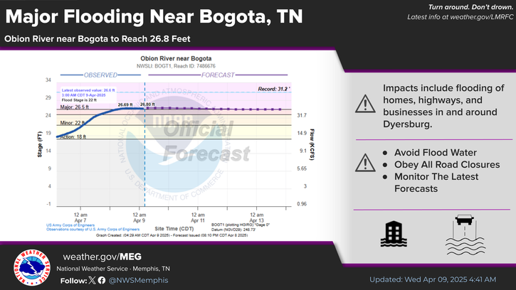
Over the past week, the Mid-South has been impacted by an unprecedented stretch of severe weather and historic rainfall. This prolonged event has led to multiple devastating tornadoes, damaging winds, destructive hail, and widespread, ongoing flooding across much of the region. Read More >

Click a location below for detailed forecast.

Last Map Update: Wed, Apr 9, 2025 at 5:02:30 am CDT


A Slight Risk for severe storms is in place for the entire Mid-South on Thursday. Large hail and damaging winds are the main concerns, but a weak tornado cannot be ruled out.
Ongoing flooding will continue to be an issue Thursday. However, storm total rainfall less than 0.5 inches will limit worsening conditions.
Major flooding continues in the Dyersburg, Tennessee area. For the latest stage and forecasts for the North Fork Forked Deer River at Dyersburg go to: https://water.noaa.gov/gauges/DYET1
The Obion River near Bogota, Tennessee will remain in Major Flood Stage. For the latest gauge information, visit: www.water.noaa.gov/gauges/BOGT1

graphical hazard
Graphical Hazards
probabilistic
Probabilistic
current weather
Current Weather
be prepard
Being Prepared
estar preparado
Estar Preparado
safety
Weather Safety

Text Product Selector (Selected product opens in current window)

 Current Weather Observations...
Location Time
(CDT)
Weather Vsby.
(SM)
Temp.
(ºF)
Dewpt.
(ºF)
Hum.
(%)
Wind
(mph)
Wind Chill / Heat Index
(ºF)
Pres.
(in)
Memphis TN03:54Clear10443057E 541 [WC]30.16
Jackson TN03:53Clear10353184CALM-30.18
Jonesboro AR03:5310353184CALM-30.16
Tupelo MS03:53Clear10383382CALM-30.16
West Memphis, AR03:53Clear10403479SSE 3-30.15
Blytheville, AR03:53Clear10433264SSE 3-30.17
Dyersburg, TN03:56Clear10412961CALM-30.19
Olive Branch, MS04:35Clear10393069ESE 535 [WC]30.16
Oxford, MS04:35Clear10353286ESE 530 [WC]30.18