National Weather Service United States Department of Commerce

Flooding Continues in the Central U.S.; Critical Fire Weather in the Plains

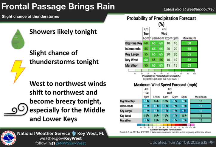
From the Lower Mississippi into the Ohio Valley, widespread moderate to major river flooding is ongoing and will continue through at least late week. Cold temperatures, near or below freezing Wednesday morning will be felt across areas that were impacted by the recent multi-day storms. Dry conditions and gusty winds will contribute to critical fire weather Wednesday over parts of the Plains. Read More >

Click a location below for detailed forecast.

Last Map Update: Tue, Apr 8, 2025 at 10:30:12 pm EDT

Frontal Passage Brings Rain
Slight chance of thunderstorms

- Showers likely tonight.
- Slight chance of thunderstorms tonight.
- West to northwest winds shift to northwest and become breezy tonight, especially for the Middle and Lower Keys.
UPPER KEYS:
TONIGHT...Showers likely with a slight chance of thunderstorms. Lows in the mid to upper 60s. Southwest to west winds 10 to 15 mph, becoming northwest and increasing to near 15 mph. Chance of rain 60 percent.
MIDDLE AND LOWER KEYS:
TONIGHT...Showers likely with a slight chance of thunderstorms. Becoming breezy. Lows near 70. West to northwest winds 10 to 15 mph, becoming northwest to north and increasing to 15 to 20 mph. Chance of rain 60 percent.
SMALL CRAFT SHOULD EXERCISE CAUTION FOR INCREASING WINDS!
WINDS HIGHER AND BAY WATERS ROUGH IN AND NEAR SHOWERS AND THUNDERSTORMS!
TONIGHT...Southwest to west winds near 15 knots, decreasing briefly to near 10 knots in the evening, then becoming northwest to north and increasing to 15 to 20 knots. Bay waters a moderate chop, becoming choppy. Winds higher and bay waters rough in and around numerous showers and isolated thunderstorms.
SMALL CRAFT ADVISORY IN EFFECT!
WINDS AND SEAS HIGHER IN AND NEAR SHOWERS AND THUNDERSTORMS!
TONIGHT...West to northwest winds near 15 knots, becoming northwest to north and increasing to near 20 knots. Seas 1 to 2 feet, building to 2 to 4 feet, occasionally to 5 feet. West of the Marquesas Keys, seas 3 to 4 feet, occasionally to 6 feet, building to 4 to 6 feet, occasionally to 8 feet. Nearshore waters a moderate chop, becoming rough. Winds and seas higher in and around numerous showers and isolated thunderstorms.
SMALL CRAFT ADVISORY IN EFFECT!
WINDS AND SEAS HIGHER IN AND NEAR SHOWERS AND THUNDERSTORMS!
WESTERN HAWK CHANNEL:
TONIGHT...West to northwest winds near 15 knots, becoming northwest to north and increasing to near 20 knots. Seas 2 to 3 feet. West of Cosgrove Shoal Light, seas 3 to 5 feet, occasionally to 6 feet, building to 5 to 6 feet, occasionally to 8 feet. Nearshore waters a moderate chop, becoming rough. Winds and seas higher in and around numerous showers and isolated thunderstorms.
EASTERN HAWK CHANNEL:
TONIGHT...Southwest to west winds near 15 knots, becoming northwest and increasing to 15 to 20 knots after midnight. Seas 1 to 2 feet. Nearshore waters a moderate chop, becoming choppy. Winds and seas higher in and around numerous showers and isolated thunderstorms.
SMALL CRAFT ADVISORY IN EFFECT!
WINDS AND SEAS HIGHER IN AND NEAR SHOWERS AND THUNDERSTORMS!
WESTERN STRAITS:
TONIGHT...West to northwest winds near 15 knots, becoming northwest to north and increasing to near 20 knots. Seas 3 to 5 feet, occasionally to 7 feet, building to 4 to 6 feet, occasionally to 8 feet. Wave Detail: West to northwest 5 feet at 6 seconds and east to southeast 1 foot at 5 seconds. Winds and seas higher in and around numerous showers and isolated thunderstorms..
EASTERN STRAITS:
TONIGHT...Southwest to west winds 10 to 15 knots, becoming northwest and increasing to 15 to 20 knots. Seas 1 to 2 feet, building to 2 to 3 feet. Wave Detail: West to northwest 3 feet at 5 seconds and southeast 1 foot at 4 seconds. Winds and seas higher in and around widespread showers and isolated thunderstorms.
SMALL CRAFT ADVISORY IN EFFECT!
WINDS AND SEAS HIGHER IN AND NEAR SHOWERS AND THUNDERSTORMS!
TONIGHT...Northwest to north winds 15 to 20 knots, increasing to near 20 knots. Seas 3 to 5 feet, occasionally to 6 feet, building to 4 to 6 feet, occasionally to 8 feet. Wave Detail: Northwest 6 feet at 7 seconds. Winds and seas higher in and around scattered showers and isolated thunderstorms.


Text Product Selector
(Selected product opens in a new window) 


Sunrise & Sunset

Sunrise & Sunset


Moon Rise & Set

Moon Rise & Set


Moon Illumination

Moon Illumination


Tide Information

Tide Information


Tropical

Tropical


Coastal Flooding

Coastal Flooding


Tallship

Marine


Nearshore Waves

Wave Prediction


Thumbnail for a local waterspouts website, showing 4 waterspouts.

Waterspouts


Airplane

Aviation


Key West & Marathon Climographs 2020

Climographs


Tropical

Forecast Discussion


NOAA Weather Radio

NOAA Weather Radio